Vertical Motion and the Three Layered Ocean
We have looked at evidence for horizontal currents that move along the surface of the ocean to redistribute heat. Vertical currents also move water from place to place. Upwelling currents driven by the wind are one mechanism for bringing deeper water to the ocean surface. Vertical motions can also be induced by density instabilities in the water column. An unstable water column occurs where denser water overlies less dense water. Throughout much of the ocean, vertical motions are inhibited by a stable density structure.
In the open ocean, temperature has the largest effect on water density. Based on temperature variations, the ocean can be divided into three depth zones:
The surface layer usually around 100 to 200 m thick. Much of the time the surface layer is mixed by wind, waves, and currents, so it is known as the mixed layer.
The intermediate layer lies below the surface layer to a depth of around 1,500 m. The main thermocline, a zone of transition between warm surface water and the cold water below, lies in the intermediate layer.
The deep and bottom layers lie below the intermediate layer. The deep water and bottom water are different, but they are similar in being uniformly cold, typically less than 4°C.
The three zones produce a stable water column where less dense (warm) water overlies more dense (cold) water. It is primarily at high (polar) latitudes, where the three zones are poorly developed, that the density instabilities that stimulate vertical motions occur.
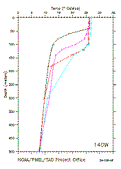
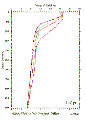
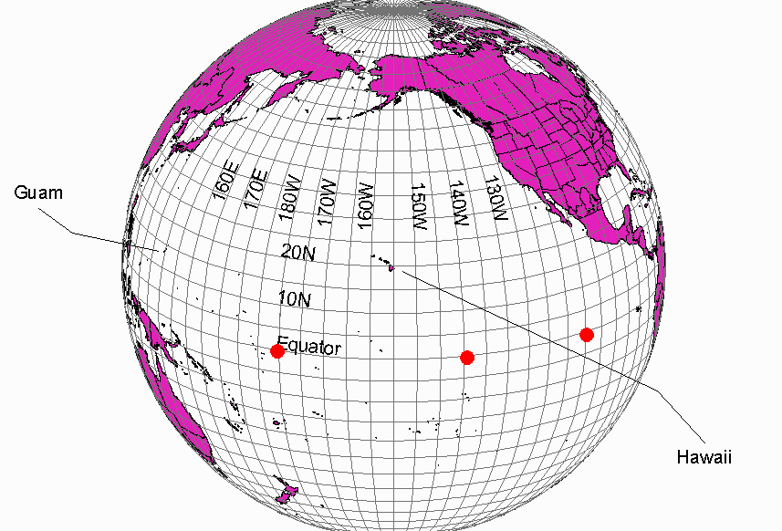
The graphs below show water-temperature measurements sampled in a vertical column along the equatorial Pacific Ocean, at 110 W longitude, 140 W longitude, and 180 W longitude. See a world map for sampling locations. The data were collected on 22 and 23 February 1996. Four to six sampling sites are included on each diagram. The sites range from 9 degrees North to 8 degrees South Latitude. If necessary, widen viewing window so that images are adjacent to each other. Click on the left image to obtain larger-sized versions.
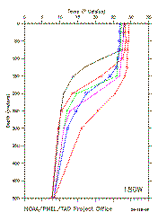
180° W Longitude
140° W Longitude
110° W Longitude

- On the graphs, mark the depths of the boundaries between the surface zone, thermocline, and deep zone. Label the three (3) zones.
- What changes do you observe from east to west along the equator in the Pacific Ocean?
Why do you think these changes occur? (Hint: Ocean Circulation Map)