Sea Surface Temperatures (SST)
Sea-surface temperatures (SSTs) are easily measured by satellites and can show the locations of currents that move across the ocean's surface. The following images show examples of Earth's major currents, delineated by measured differences in sea-surface temperatures.
Sea Surface Temperature Data
The NOAA polar-orbiting satellites (POES) have been collecting sea surface temperature data for over 22 years. This animation is a compilation of that data from January 1985 - January 2007. Of note are the changes in the Gulf Stream, El Nino and La Nina cycles in the Pacific, and the seansonal changes in sea ice cover.
- Describe the general pattern of sea surface temperatures in the ocean.
- Examine the zone of warm water along the equator for the world sea-surface temperatures (SSTs).
Why does this zone widen to the west in each ocean; for example, in the Pacific Ocean? (Hint: look at the Atmospheric Circulation Diagram and the Surface Currents Map.) Perturbations to this pattern are involved with the El Niño climatic condition.
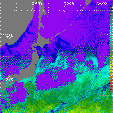
Kuroshio Current
The image to the right uses sea-surface temperature measurements to illustrate the location of the Kuroshio current. The Kuroshio current is called a western boundary current (it moves along the west side of an ocean). Click on the image to obtain a larger-sized version. Sea-surface temperatures are in degrees Celsius.
- What is the geographical location of the Kuroshio Current?
Is the Kuroshio Current a warm-water or a cold-water current? [Provide a temperature range.]
Do you see any evidence for the influence of another current? If so, what is its name and its temperature? (Refer to the Surface Currents Map.)
Gulf Stream Current
The images below use sea-surface temperature measurements to show another western boundary current, the Gulf Stream. The two images show data collected 6 days apart, on 19 February (left side) and 25 February (right side) in 1996. Major currents such as the Gulf Stream can be compared to rivers in the ocean, although they can transport incredibly huge amounts of water from place to place. For example, the Gulf Stream transports more than 150 million cubic meters of water per second, compared to a flow of 0.6 meters per second for all of the rivers that flow into the Atlantic Ocean. On these images the Labrador Current, as well as the Gulf Stream Current, is visible. Click on the left image to obtain larger-sized versions.
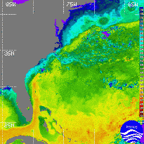
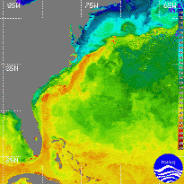
- What is the temperature range of the Gulf Stream current?
- What is the temperature range of the Labrador current?
- Describe what changes occur in the currents during the 6-day period between the two images. For example, notice what happens with the ring of Gulf Stream water enclosed in the colder water.
- Describe the boundaries of the Gulf Stream. For example, are they sharp or diffuse; straight or meandering? Explain.
Agulhas Current
In the image to the right, sea-surface temperatures are used to show the Agulhas Current at the tip of Africa. Measurements were collected by satellite in 21 February 1996. Click on the image to obtain a larger version.
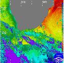
- Explain why the east coast of Africa is warm, even as far south as South Africa relative to the west coast of Africa which is much colder even though both coast are at the same latitude.
- This current was especially important historically, because it flows down the east coast of Africa. Use the Sea Surface Temperature Simulation for the Agulhas Current to explain why early sailors from Europe, trying to find a way around the southern tip of Africa failed and died in large numbers due to the Agulhas Current.